International Gateway of the Americas (aka)Las Americas
ClubHombre.com:
Tijuana:
Advice/Questions/Commentary:
International Gateway of the Americas (aka)Las Americas
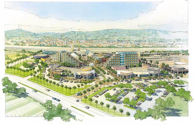
Strategically located on the world's busiest border crossing, San Diego, California/Tijuana, Mexico, with more than 86 million crossings per year, Las Americas, a major multi-use project, is now underway.
(Las Americas, formerly known as International Gateway of the Americas.)
Project Facts
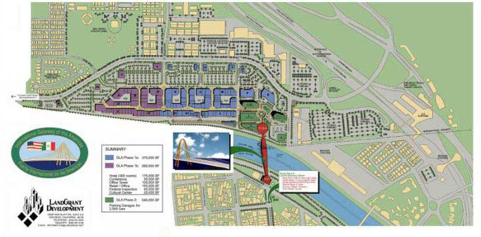
Master Plan
Phase 1 of the project will include a 625,000 square-foot open-air retail mall featuring decorative esplanades, inviting courtyards and festive public plazas. Tenants in the retail mall include Tommy Hilfiger, The Gap, Old Navy, Banana Republic, Nautica, Polo Jeans, Liz Claiborne, Nike, Guess? and many other welll-known American, European and Mexican retailers. Additionally, Las Americas will offer a wide variety of dining and entertainment options, featuring a food court with a sampling of ethnic foods and a number of themed restaurants, including Outback Steakhouse. The retail mall is scheduled to open November 2001.
Phase II of the project proposes the building of the Bridge of the Americas, a landmark suspension bridge utilizing the latest in technology and design. In addition to the pedestrian bridge, this phase will involve the development of a variety of facilities, including a transportation terminal to facilitate buses, taxis and private vehicle traffic, duty- free retail shopping, an office tower and a 300-room hotel and conference center. This phase will also include the launch of a cultural center to provide artistic and educational exhibits, displays and live performances of music, dance and drama representing both countries.
Trade Area
There are approximately 4.5 million residents in the San Diego/Tijuana region, including nearly 2 million residents in the primary trade area (10-mile radius) of Las Americas.
The San Diego/Tijuana cross-border population is more than two times greater than that of any other cross-border city pair along the 2,000-mile U.S./Mexico border.
Retail expenditure in the primary trade area is greater than $4 billion per year.
South San Diego County, the heart of the primary trade area, is projected to grow by 42% between 2000 and 20005, and by 83% during the next 17 years.
Site Plan
Vicinity Map
Source:
LandGrant Development
12625 High Bluff Drive, Suite 212
San Diego, California 92130-2054
PH. (858) 481-0094
FAX. (858) 481-3108
E-mail: Info@InternationalGatewayoftheAmericas.com
| By Harold_Johnson on Tuesday, July 02, 2002 - 07:03 pm: Edit |
Yeah, yeah, yeah. But how will this effect my mongering?
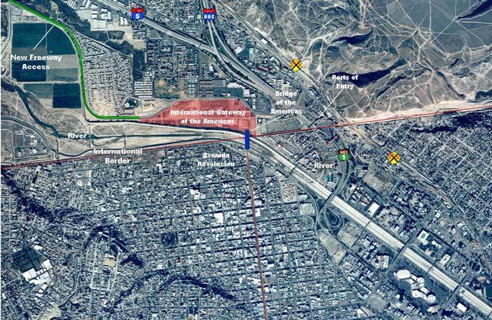
That's why I wanted to get the Vicinity Map and the Site Plan on here. From those you can see all the major replanning is on the American side.
The big thing that would effect us mongers is building of the bridge. That doesn't get started until phase2. "The second phase of the project would include a landmark pedestrian bridge over the Tijuana River still subject to federal and local government approval".(We all know how fast government moves)
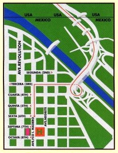
Do you know where La tropa, Chicago Club, and the Adelita Bars are on the map(I know it's hard to see)?
Anyway, point being all three of these bars are less than a block and a half away. La Tropa is about 200 feet from Revolution. All or most of these bars will be effected sometime in the next couple of years.
| By Hippie on Tuesday, July 02, 2002 - 08:01 pm: Edit |
My personal opinion is that the bridge is unlikely to happen. This was planned well before 9/11 and the new security consciousness. Even then, they did not have government approval lined up, but every time I read or heard anything about the project, the people behind it tried to make it sound as if the bridge was a done deal. It just sounds kind of fishy, since I have never heard a single comment form a US government official on the matter, but I could be wrong.
| By Hippie on Tuesday, July 02, 2002 - 08:23 pm: Edit |
Snapper asked, "Do you know where La tropa, Chicago Club, and the Adelita Bars are on the map(I know it's hard to see)?"
I assume you are referring to the large aerial photo, since only La Tropa would be on the small map you posted. I believe that the final "n" in "Avenida Revolucion" is located on the intersection of Constitucion and Baja California, the next street north of Coahuila. The white line pointing to Revo passes right over CC. La Tropa is just a tad left of where that white line stops. AB would be about even with the second "o" in "Revolucion," one street down.
Yes, the white line is a good way to point it out.